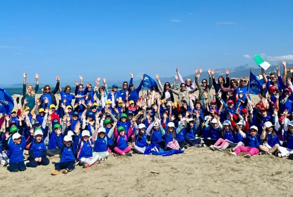
Teveredamare

Ponte Cavour

Ponte CavourIta Il ponte prende il nome da Camillo Benso Conte di Cavour, uno dei più importanti fautori dell'Unità d'Italia.
Costruito nel 1896, su progetto dall’Arch. Vescovali, per collegare la riva sinistra del Tevere con la zona di Prati di Castello in pieno sviluppo edilizio, ha una struttura in mattoni e malta cementizia rivestita di travertino ed è lungo 110,10 m e largo 20 m.

Il Porto di Ripetta
Per costruire i muri di sponda del fiume nel 1893 è stato necessario interrare quasi intatto il porto di Ripetta che, fino agli inizi del '900, era uno dei due approdi fluviali di Roma, l'altro è Ripa Grande a sud, che consentiva il collegamento della città con l'alto bacino del Tevere.
La nascita del porto si fa risalire all'imperatore Aureliano (III sec.) che, nella costruzione della cinta muraria urbana, lasciò 4 varchi (posterule) lungo il tratto fluviale del muro sulla riva sinistra. La trasformazione da semplice approdo in terra battuta a vero e proprio porto fluviale con moli, banchine e fontana, si deve al papa Clemente XI, G. F. Albani (1700-1721), che nel 1703 incaricò l'architetto Alessandro Specchi. Le uniche testimonianze del settecentesco porto, costituite dalla fontana e dalle due colonne con le altezze delle piene del fiume, furono sistemate nell'attuale terrazzamento all’incrocio del lungotevere con via della Scrofa, quando fu demolito.

Le alluvioni
Nell'arco di tempo che va dal 414 a.C., data in cui si hanno le prime notizie sulle inondazioni del Tevere, al 1937, si sono verificate circa 90 inondazioni. Questi eventi erano spesso accompagnati da strane visioni di serpenti ed immensi dragoni emergenti dalle acque limacciose del fiume. Molto più realisticamente causarono sempre ingenti danni alla città e lutti per epidemie e pestilenze.
A partire dal 1782 si iniziò a segnare le fluttuazioni del livello del fiume; tali osservazioni divennero più sistematiche con l’installazione al porto di Ripetta, nel 1821, dell’idrometro, costituito da lastre di marmo graduate in metri e centimetri, su cui venivano fatte letture giornaliere. Con lo smantellamento del porto e la costruzione dei muraglioni le aste idrometriche furono spostate: quelle che segnano il livello fino a 18 m sono tuttora ubicate sul muraglione vicino alle scalette che scendono sulla banchina sinistra, a monte del ponte.
Le aste più alte sono state riposizionate sulla parete esterna destra della chiesa di San Rocco: i diversi livelli di piena segnati sull’asta sono effettivamente le altezze raggiunte dal fiume nel corso del tempo.

Eng The bridge gets its name from Camillo Benso Count of Cavour, one of the most important promoters of the Unification of Italy.
Built in 1896 to a plan by Architect Vecovali, to link the left bank of the Tiber with the Prati di Castello area, undergoing a building boom, its structure is in bricks and cement faced with travertine and it is 110.10 m long and 20 m wide.

The Porto di Ripetta
To build the retaining walls of the river in 1893 it was necessary to bury almost completely the Porto di Ripetta that, until the beginning of 1900, had been one of the two river approaches to Rome - the other is Ripa Grande on the south - which made it possible to connect the city with the upper basin of the Tiber.
The origin of the port goes back to Emperor Aurelian (3rd century) who, when building the city walls, left 4 openings (posterule) along the riverside stretch of the wall on the left bank. It was Pope Clement XI, G.F. Albani (1700-1721) who, in 1703, commissioned the architect Alessandro to transform it from a simple well-trodden earthen landing place to a real river port with piers, quays and fountains. The only remnants of the 18th century port, the fountain and two of the columns showing the river's flood levels, were placed in what is now the terracing of the intersection of the Lungotevere with Via della Scrofa, when it was demolished .
The floods

During the period from 414 BC, the first date on which we have information about the Tiber flooding, until 1937, there were 90 floods. These events were often accompanied by strange visions of snakes and enormous dragons emerging from the slimy waters of the river. More realistically, they always caused heavy damage to the city, not to mention epidemics and plagues.
In 1782 the fluctuations in the level of the river started being recorded; these observations became more systematic in 1821 with the installation in the Porto di Ripetta of a water gauge consisting of slabs of marble marked out in metres and centimetres, on which daily readings were taken. When the port was dismantled and the embankments built, the water-gauges were moved: the ones showing the level up to 18 m are still situated on the embankment near the steps that go down to the left quay, before the bridge.
The higher columns were moved to the outside right-hand wall of the church of Saint Roch: the various flood levels marked on the column are the levels actually reached by the river over the years.

Porto di Ripetta in una riproduzione del ‘700 di Gaspar Van Wittel (1652-1763) - Porto di Ripetta in an 18th century drawing by Gaspar Van Wittel (1652-1760)

Ponte Marconi Ponte dell'Industria Ponte Testaccio Ponte Sublicio Ponte Palatino Ponte Cestio Ponte Fabricio Ponte Garibaldi Ponte Sisto Ponte Mazzini Ponte Principe Amedeo Ponte Vittorio Emanuele II Ponte Sant'Angelo Ponte Umberto I Ponte Cavour Ponte Margherita Ponte Pietro Nenni Ponte Matteotti Ponte del Risorgimento Ponte Duca d'Aosta Ponte Milvio Ponte Flaminio Ponte Tor di Quinto Ponte Castel Giubileo
01 Ponte Castel Giubileo
02 Ponte Tor di Quinto
03 Ponte Flaminio
04 Ponte Milvio
05 Ponte Duca d'Aosta
06 Ponte del Risorgimento
07 Ponte Matteotti
08 Ponte Pietro Nenni
09 Ponte Margherita
10 Ponte Cavour
11 Ponte Umberto I
12 Ponte Sant'Angelo
13 Ponte Vittorio Emanuele II
14 Ponte Principe Amedeo
15 Ponte Mazzini
16 Ponte Sisto
17 Ponte Garibaldi
18 Ponte Fabricio
19 Ponte Cestio
20 Ponte Palatino
21 Ponte Sublicio
22 Ponte Testaccio
23 Ponte dell'Industria
24 Ponte Marconi
  © Copyright Marevivo 2004 - Note Legali  
   
 
MediaWave S.à r.l.
Associazione Ambientalista Marevivo
Lungotevere A. da Brescia
Scalo de Pinedo - 00196 Roma
Tel. 06 3202949 3222565 Fax 06 3222564